By Sierra Rayne ——Bio and Archives--May 3, 2014
Canadian News, Politics | CFP Comments | Reader Friendly | Subscribe | Email Us


 I have used this database for a number of publications, and even a cursory examination of the temperature and precipitation records for the relative small number of stations available shows the dataset is very incomplete. At many, if not most, AHCCD climate stations, there are a number of gaps within and throughout the historical record. Keep in mind these data are already pre-homogenized, meaning that if Environment Canada is publishing a gap (or more commonly, many gaps) in the historical record at a single station, it means the temperature or precipitation value for that month could not be reliably estimated by comparison to other, nearby stations. And a gap in a single month means the corresponding seasonal estimate cannot be made for that year, and that the annual value for that year also cannot be calculated.
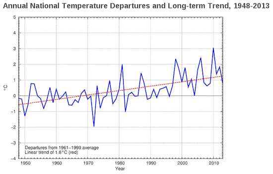
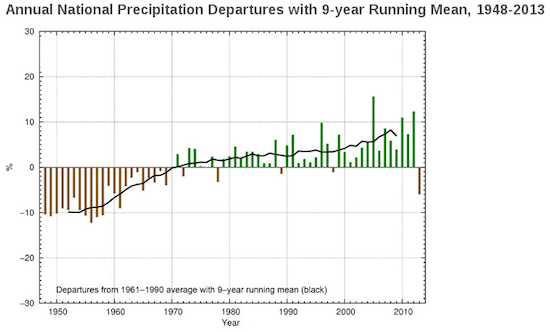
Thus, using the available AHCCD database (which is the one that must be employed to determine a historical series of "national average" temperatures and precipitation amounts), it is impossible to calculate a complete suite of historical annual or seasonal temperatures for even a modest subset of the total number of stations. And note there are only 338 total temperature stations in the AHCCD database for a highly topographically diverse nation of 10 million km2, and I count at least 58 (or almost one-fifth of the total) of these whose records didn't begin until after 1948 (which is when that "national temperature" graph begins). Similarly, there are only 463 total precipitation stations in the database, of which 83 have records beginning in 1949 or later (some as recently as 1977), or after the start date of the "national average" graphs.
These climate stations are simply not completely representative of Canada's high climate heterogeneity, particularly since the stations are generally located near populated areas that are convenient places to live (i.e., valley bottoms versus mountaintops, etc.), and are not reflective of local and regional topography. One also notes that the AHCCD database only contains data up to -- at most -- 2012 (and very often stations are not yet up to this date), and yet Environment Canada is showing "national average" temperature and precipitation data that already includes all of 2013. How can this be?
Consequently, I have no idea how a scientifically valid "national average" temperature or precipitation record dating back to 1948 can be calculated for the second largest nation on the planet. Heck, I cannot understand how even meaningful and reliable regional and local averages (also provided on the Environment Canada website) can be estimated.
Either Environment Canada should place a full technical paper with downloadable complete data appendices available to the public on its website that explains in detail how "national average" climate variables have been calculated for the country, or remove this questionable work from government websites. Pick one option, as the mystery science at present is unacceptable.
I have used this database for a number of publications, and even a cursory examination of the temperature and precipitation records for the relative small number of stations available shows the dataset is very incomplete. At many, if not most, AHCCD climate stations, there are a number of gaps within and throughout the historical record. Keep in mind these data are already pre-homogenized, meaning that if Environment Canada is publishing a gap (or more commonly, many gaps) in the historical record at a single station, it means the temperature or precipitation value for that month could not be reliably estimated by comparison to other, nearby stations. And a gap in a single month means the corresponding seasonal estimate cannot be made for that year, and that the annual value for that year also cannot be calculated.
Thus, using the available AHCCD database (which is the one that must be employed to determine a historical series of "national average" temperatures and precipitation amounts), it is impossible to calculate a complete suite of historical annual or seasonal temperatures for even a modest subset of the total number of stations. And note there are only 338 total temperature stations in the AHCCD database for a highly topographically diverse nation of 10 million km2, and I count at least 58 (or almost one-fifth of the total) of these whose records didn't begin until after 1948 (which is when that "national temperature" graph begins). Similarly, there are only 463 total precipitation stations in the database, of which 83 have records beginning in 1949 or later (some as recently as 1977), or after the start date of the "national average" graphs.
These climate stations are simply not completely representative of Canada's high climate heterogeneity, particularly since the stations are generally located near populated areas that are convenient places to live (i.e., valley bottoms versus mountaintops, etc.), and are not reflective of local and regional topography. One also notes that the AHCCD database only contains data up to -- at most -- 2012 (and very often stations are not yet up to this date), and yet Environment Canada is showing "national average" temperature and precipitation data that already includes all of 2013. How can this be?
Consequently, I have no idea how a scientifically valid "national average" temperature or precipitation record dating back to 1948 can be calculated for the second largest nation on the planet. Heck, I cannot understand how even meaningful and reliable regional and local averages (also provided on the Environment Canada website) can be estimated.
Either Environment Canada should place a full technical paper with downloadable complete data appendices available to the public on its website that explains in detail how "national average" climate variables have been calculated for the country, or remove this questionable work from government websites. Pick one option, as the mystery science at present is unacceptable.View Comments
Sierra Rayne holds a Ph.D. in Chemistry and writes regularly on environment, energy, and national security topics. He can be found on Twitter at @srayne_ca