
 John Treadwell Dunbar is a freelance writer
The Coos Bay Coast, Oregon
 With a seemingly endless flow of money at his disposal, an obsessive penchant for pretty flowers blooming in manicured gardens, and not one, but two, ostentatious mansions to brag about, lumber baron Louis Simpson assembled and cultivated one of the grandest estates on the American West Coast between the 1920s and 1942. Perched on a sprawling bluff high above the raging Pacific, Simpson's masterpiece, known to the 21st century as Shore Acres, commanded stunning views of rugged headlands, teeming rookeries, offshore islands and sea stacks, and an enormous reef awash with thousands of feathered fowl and vast herds of marine mammals – seals and lions. Living in pinniped heaven, these blubbery beasts of the deep blue sea haul out now as they did back then, and lounge about on rocky ledges and in isolated coves under temperamental gray skies that are heavy, long and wide, but which mercifully turn blue during summer and fall.
- Tuesday, May 15, 2012
 Standing alone for more than 200 years in the harsh desert of southern Arizona above the Santa Cruz River on the Tohono O’odham Reservation ten miles south of Tucson, the Mission San Xavier del Bac is considered to be the finest example of Spanish Colonial architecture in the United States, and the oldest extant European structure in the state of Arizona.
Once rotting under the burdens of time and the elements - scorching heat, torrential monsoon rains, and well-intentioned, though misguided, encasement in an exterior cement veneer during years past - significant restoration efforts are returning the White Dove of the Desert to its original ecclesiastical glory, resurrected, as it were, with love, sweat, and much-needed financial contributions from private, and ever-dwindling public, resources.
Standing alone for more than 200 years in the harsh desert of southern Arizona above the Santa Cruz River on the Tohono O’odham Reservation ten miles south of Tucson, the Mission San Xavier del Bac is considered to be the finest example of Spanish Colonial architecture in the United States, and the oldest extant European structure in the state of Arizona.
Once rotting under the burdens of time and the elements - scorching heat, torrential monsoon rains, and well-intentioned, though misguided, encasement in an exterior cement veneer during years past - significant restoration efforts are returning the White Dove of the Desert to its original ecclesiastical glory, resurrected, as it were, with love, sweat, and much-needed financial contributions from private, and ever-dwindling public, resources.
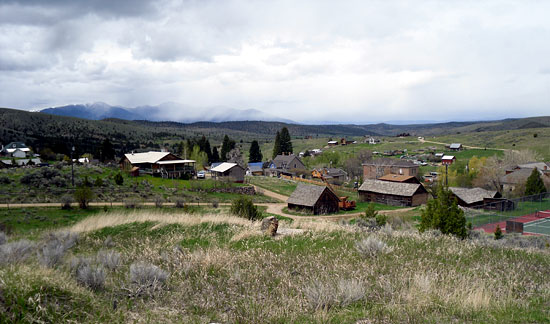
 Not just another friendly village in Southwest Montana surrounded by grass-fed Herefords and Black Angus beef, Ennis (pop. 1,000) was crowned a Top 20 Western Town by Cowboy Magazine in 2009, and deservedly so. It's likely you've seen Ennis without realizing it.
Back when the big guy was kicking and chopping his way to action-hero fame, Steven Seagal, with nearly 40 films to his name, filmed "The Patriot" (1998) here and down south on his stunning 18,000-acre Sun Ranch, which he sold off in '98. The plot is relatively straightforward: Patriotic country doctor saves the world from a deadly virus by discovering a cure and beating up evil paramilitary militiamen in the process. Nothing wrong with that.
Not just another friendly village in Southwest Montana surrounded by grass-fed Herefords and Black Angus beef, Ennis (pop. 1,000) was crowned a Top 20 Western Town by Cowboy Magazine in 2009, and deservedly so. It's likely you've seen Ennis without realizing it.
Back when the big guy was kicking and chopping his way to action-hero fame, Steven Seagal, with nearly 40 films to his name, filmed "The Patriot" (1998) here and down south on his stunning 18,000-acre Sun Ranch, which he sold off in '98. The plot is relatively straightforward: Patriotic country doctor saves the world from a deadly virus by discovering a cure and beating up evil paramilitary militiamen in the process. Nothing wrong with that.
 They came. They built. They vanished. Unique among Native American prehistoric civilizations, the gradual rise and terribly swift fall of the Ancient Pueblo Indians of America's Southwest, the Anasazi, continues to transfix modern man. Understandably, admiration for the ancients' beautiful architectural triumphs and preconceived notions about this relatively peaceful utopian civilization of farmers have been tarnished by what is considered heresy among many archeologists and self-proclaimed descendants of the Anasazi - the Hopi, Zuni and other pueblo peoples.
According to experts in the field, and others, it appears as though they ate each other, or were sacrificed and devoured between the ninth and 12th centuries by a ruling elite of Mesoamerican cannibals intent on maintaining their grip on power through sheer terror. Or maybe they were gobbled up in the 1100s by invading hordes from Old Mexico, the Toltecs. Regardless of who perpetrated this unseemly culinary tradition, or why, it's virtually certain that human sacrifice and the feast that followed were not limited to country folk in far-flung communities, but likely practiced in a big way in the big city at Chaco Canyon as well. The debate rages on.
They came. They built. They vanished. Unique among Native American prehistoric civilizations, the gradual rise and terribly swift fall of the Ancient Pueblo Indians of America's Southwest, the Anasazi, continues to transfix modern man. Understandably, admiration for the ancients' beautiful architectural triumphs and preconceived notions about this relatively peaceful utopian civilization of farmers have been tarnished by what is considered heresy among many archeologists and self-proclaimed descendants of the Anasazi - the Hopi, Zuni and other pueblo peoples.
According to experts in the field, and others, it appears as though they ate each other, or were sacrificed and devoured between the ninth and 12th centuries by a ruling elite of Mesoamerican cannibals intent on maintaining their grip on power through sheer terror. Or maybe they were gobbled up in the 1100s by invading hordes from Old Mexico, the Toltecs. Regardless of who perpetrated this unseemly culinary tradition, or why, it's virtually certain that human sacrifice and the feast that followed were not limited to country folk in far-flung communities, but likely practiced in a big way in the big city at Chaco Canyon as well. The debate rages on.
 Twenty years ago I happily stumbled upon the great little Western-themed town of Winthrop in the wonderful Methow Valley. True to its mining and ranching roots, Winthrop has been converted into a portal into the past showcasing covered walkways, Wild West saloons, and Main Street facades. Easily passing for the originals, and some are the real deal, weather-streaked barnwood exteriors scream, "Giddy-up, pardner!" Scratching my head in bewilderment, I thought I landed on a back lot at Universal Studios. All that was missing was my gelded Appaloosa, spurs to go with the pointy boots and some chaw dribbling down my chin. And one of them big hats.
That day I came in over the Cascade Mountains from Puget Sound along State Highway 20, just another line on the map in need of exploring, and part of the fabled Cascade Loop Scenic Highway through North Cascades National Park dripping with 300 glaciers and countless waterfalls. Rolling west to east through a two-million acre swath of wild country of various bureaucratic designations, I vaguely remember a long, meandering climb, almost always up, that took me through dense Douglas fir, and nearer the summits, alpine meadows awash in lupine and fireweed. In keeping with the winter-waterlogged Pacific Northwest, everything was intensely green. There were few homes along the way to Winthrop, and back then, little traffic - the way I like it.
Twenty years ago I happily stumbled upon the great little Western-themed town of Winthrop in the wonderful Methow Valley. True to its mining and ranching roots, Winthrop has been converted into a portal into the past showcasing covered walkways, Wild West saloons, and Main Street facades. Easily passing for the originals, and some are the real deal, weather-streaked barnwood exteriors scream, "Giddy-up, pardner!" Scratching my head in bewilderment, I thought I landed on a back lot at Universal Studios. All that was missing was my gelded Appaloosa, spurs to go with the pointy boots and some chaw dribbling down my chin. And one of them big hats.
That day I came in over the Cascade Mountains from Puget Sound along State Highway 20, just another line on the map in need of exploring, and part of the fabled Cascade Loop Scenic Highway through North Cascades National Park dripping with 300 glaciers and countless waterfalls. Rolling west to east through a two-million acre swath of wild country of various bureaucratic designations, I vaguely remember a long, meandering climb, almost always up, that took me through dense Douglas fir, and nearer the summits, alpine meadows awash in lupine and fireweed. In keeping with the winter-waterlogged Pacific Northwest, everything was intensely green. There were few homes along the way to Winthrop, and back then, little traffic - the way I like it.
 This was a rut I was grateful to be stuck in one crisp, blue-sky morning in eastern Wyoming. Standing deep in a trough on a sparsely wooded hill overlooking the North Platte River near the outskirts of Guernsey, I felt the earth rumble as oxen mooed, whips cracked, and covered wagons creaked up the steep rutted incline hauling heavy loads of the essentials, and the trivial. Hardened women in bonnets and long skirts followed coughing in the dust, and men in hats on horses yelled at their livestock and encouraged children and the old staggering to keep pace.
Among this rolling wave of humanity were hundreds of poor English and Scandinavian Mormons on foot who had no idea what awaited them in October of 1856 as they pushed and pulled two-wheeled carts with bloody hands ever-onward to Zion and the Valley of the Salt Lake for 1,300 tiresome miles in the ultimate test of their faith.
This was a rut I was grateful to be stuck in one crisp, blue-sky morning in eastern Wyoming. Standing deep in a trough on a sparsely wooded hill overlooking the North Platte River near the outskirts of Guernsey, I felt the earth rumble as oxen mooed, whips cracked, and covered wagons creaked up the steep rutted incline hauling heavy loads of the essentials, and the trivial. Hardened women in bonnets and long skirts followed coughing in the dust, and men in hats on horses yelled at their livestock and encouraged children and the old staggering to keep pace.
Among this rolling wave of humanity were hundreds of poor English and Scandinavian Mormons on foot who had no idea what awaited them in October of 1856 as they pushed and pulled two-wheeled carts with bloody hands ever-onward to Zion and the Valley of the Salt Lake for 1,300 tiresome miles in the ultimate test of their faith.
 Heralded as one of the great natural amphitheaters of the world, Cedar Breaks will take your breath away not simply because of its eroded beauty and exceptional panoramic views, but also because it sits on top of a mountain on the edge of the Markagunt Plateau at 10,300 feet above sea level where clean air is paper thin and often blows very hard and steady like it did when we visited one recent golden autumn. Bobbing and weaving, while my beleaguered heart rumbled in my chest, I leaned into the wind, gasped for air and stood in amazement at Point Supreme and the Sunset View Overlook, two places you don't want to be during a July lightning storm.
The sheer size caught me off guard the first time I inched toward the edge where the land falls away abruptly exposing terrain shaped like the folds of a curtain, plunging chutes and exposed ridges and rocky forests of freestanding buttes and fin walls, stone arches and the hoodoo army which quite frankly reminds me of Bryce Canyon; everything painted pink and orange, and shades of purple. It's a slow, methodical process focusing on individual pieces that make up the whole, assimilating the mosaic and assigning it a proper place in your mind.
Heralded as one of the great natural amphitheaters of the world, Cedar Breaks will take your breath away not simply because of its eroded beauty and exceptional panoramic views, but also because it sits on top of a mountain on the edge of the Markagunt Plateau at 10,300 feet above sea level where clean air is paper thin and often blows very hard and steady like it did when we visited one recent golden autumn. Bobbing and weaving, while my beleaguered heart rumbled in my chest, I leaned into the wind, gasped for air and stood in amazement at Point Supreme and the Sunset View Overlook, two places you don't want to be during a July lightning storm.
The sheer size caught me off guard the first time I inched toward the edge where the land falls away abruptly exposing terrain shaped like the folds of a curtain, plunging chutes and exposed ridges and rocky forests of freestanding buttes and fin walls, stone arches and the hoodoo army which quite frankly reminds me of Bryce Canyon; everything painted pink and orange, and shades of purple. It's a slow, methodical process focusing on individual pieces that make up the whole, assimilating the mosaic and assigning it a proper place in your mind.
 On a clear day the view from the headlands at the Sea Lions Cave visitors center is outstanding. But step too close to the edge and you'll get the woozies, maybe the wobblies, as you gaze down at fields of wavy green grass that plunge 300 feet to the blue Pacific churning and sloshing back-and-forth in a perpetual rolling ballet.
Look south to Florence eleven miles distant and watch the wide, empty beach recede into a misty horizon. Look north two miles and there, perched high on a bluff, is the beautiful Heceta Head Lighthouse, the most photographed and arguably most beautiful lighthouse on the Oregon Coast, though I'm not sure how that's measured. Then step in the elevator and plunge 208 feet down into the bowels of mother earth for the experience of a lifetime. Really. For a reasonable price of admission you'll be treated to the world's largest sea cave. It's not a gimmick or a circus trick, just nature hard at work carving out basalt rock one salty wave at a time. And yes, those are sea lions down there lounging about, rubbing blubber, yelping and multiplying, and stinking up the place.
On a clear day the view from the headlands at the Sea Lions Cave visitors center is outstanding. But step too close to the edge and you'll get the woozies, maybe the wobblies, as you gaze down at fields of wavy green grass that plunge 300 feet to the blue Pacific churning and sloshing back-and-forth in a perpetual rolling ballet.
Look south to Florence eleven miles distant and watch the wide, empty beach recede into a misty horizon. Look north two miles and there, perched high on a bluff, is the beautiful Heceta Head Lighthouse, the most photographed and arguably most beautiful lighthouse on the Oregon Coast, though I'm not sure how that's measured. Then step in the elevator and plunge 208 feet down into the bowels of mother earth for the experience of a lifetime. Really. For a reasonable price of admission you'll be treated to the world's largest sea cave. It's not a gimmick or a circus trick, just nature hard at work carving out basalt rock one salty wave at a time. And yes, those are sea lions down there lounging about, rubbing blubber, yelping and multiplying, and stinking up the place.
 Saturated in the arts and a rich Hispano heritage, awash in charming adobe-style architecture and 400 years of contentious history marked by occasional bloodletting of incomprehensible proportions, this quaint Northern New Mexico resort community of international fame has been known to cast a spell, a benign trance that reels back seekers and others inclined to the aesthetic year after year. But beware. If you're not careful, even you might turn your back on urban life and move here like so many globetrotters and the creative who tap into the landscape's romantic inspiration that lends itself to their creativity and peace of mind.
Painters, potters, sculptors and writers the caliber of D.H. Lawrence and John Nichols have plied their craft on the verdant high desert of the Taos Plateau, and men and women, with and without talent, continue to aspire to the works of the hand alongside temperamental actors and rebounding directors at home among the eclectic and traditional. They're a special breed, perhaps, setting themselves apart and infusing a peculiar vitality into this ancient community of narrow crooked streets and buildings flat and square and rectangular, stacked low to the ground in clean lines of smooth plaster and mud colored in tranquil tones; the browns of the earth and deeper shades of red, and pink, and the lighter scales of blue.
Saturated in the arts and a rich Hispano heritage, awash in charming adobe-style architecture and 400 years of contentious history marked by occasional bloodletting of incomprehensible proportions, this quaint Northern New Mexico resort community of international fame has been known to cast a spell, a benign trance that reels back seekers and others inclined to the aesthetic year after year. But beware. If you're not careful, even you might turn your back on urban life and move here like so many globetrotters and the creative who tap into the landscape's romantic inspiration that lends itself to their creativity and peace of mind.
Painters, potters, sculptors and writers the caliber of D.H. Lawrence and John Nichols have plied their craft on the verdant high desert of the Taos Plateau, and men and women, with and without talent, continue to aspire to the works of the hand alongside temperamental actors and rebounding directors at home among the eclectic and traditional. They're a special breed, perhaps, setting themselves apart and infusing a peculiar vitality into this ancient community of narrow crooked streets and buildings flat and square and rectangular, stacked low to the ground in clean lines of smooth plaster and mud colored in tranquil tones; the browns of the earth and deeper shades of red, and pink, and the lighter scales of blue.
 There I stood with my mouth open in disbelief on a small rise at the edge of rolling prairie near the southern end of Montana's Rocky Mountain Front. Catching my breath, I listened to loud rumbling as the earth quivered beneath the split hooves of mule deer in the hundreds thundering off in a bounding panic through twisted jack pine and brittle, tan grass and prickly pear. They ran for their lives, those beautiful mulies, through rolling foothills near towering cliffs at the entrance to the Sun River Canyon 20 miles west of Augusta - the greatest little cow town in the American West.
Suddenly it dawned on me. No wonder famed American novelist A.B. Guthrie lived on the Front near Choteau a few miles north of here. He could have lived anywhere, but settled for a slice of heaven on earth within sight of Ear Mountain. The same can be said for old what's-his-name who jets back to Montana between jokes and more recently sank roots in the shadow of this incredible, uplifted, 60-mile-long wall of mountains running north and south.
There I stood with my mouth open in disbelief on a small rise at the edge of rolling prairie near the southern end of Montana's Rocky Mountain Front. Catching my breath, I listened to loud rumbling as the earth quivered beneath the split hooves of mule deer in the hundreds thundering off in a bounding panic through twisted jack pine and brittle, tan grass and prickly pear. They ran for their lives, those beautiful mulies, through rolling foothills near towering cliffs at the entrance to the Sun River Canyon 20 miles west of Augusta - the greatest little cow town in the American West.
Suddenly it dawned on me. No wonder famed American novelist A.B. Guthrie lived on the Front near Choteau a few miles north of here. He could have lived anywhere, but settled for a slice of heaven on earth within sight of Ear Mountain. The same can be said for old what's-his-name who jets back to Montana between jokes and more recently sank roots in the shadow of this incredible, uplifted, 60-mile-long wall of mountains running north and south.
 Aside from remote stretches of sandy beach on South Padre Island, I can say without reservation that Big Bend is probably the best slice of outdoors this sprawling flat state has to offer. Cradled against a grand turn of the Rio Grande River, and sharing 118 desolate miles with Old Mexico crawling with dope smugglers and human coyotes, and wacko nut-jobs on both sides of the border laying low or on the lam, Big Bend National Park and the surrounding, inhospitable terrain elevates the wild and wooly, and the wonderful, to superlative extremes.
Harsh, prickly country unique and brash in that romantic Texas kind-of-a-way, I continue to dredge up fond memories of our autumn visit a few years ago; the solid image of a large, reddish-brown mountain lion, or cougar, sporting a long tail, gliding gently across the road on our drive down from the castle of jagged cliffs enveloping Chisos Basin. I also recall, rather vividly, getting trapped in a shoot as we scrambled into steep-walled Santa Elena Canyon while someone on the film-set down by the river's edge screamed in a blood-curdling tizzy, "Get the #@%* out of the way! We're trying to make a movie!"
Aside from remote stretches of sandy beach on South Padre Island, I can say without reservation that Big Bend is probably the best slice of outdoors this sprawling flat state has to offer. Cradled against a grand turn of the Rio Grande River, and sharing 118 desolate miles with Old Mexico crawling with dope smugglers and human coyotes, and wacko nut-jobs on both sides of the border laying low or on the lam, Big Bend National Park and the surrounding, inhospitable terrain elevates the wild and wooly, and the wonderful, to superlative extremes.
Harsh, prickly country unique and brash in that romantic Texas kind-of-a-way, I continue to dredge up fond memories of our autumn visit a few years ago; the solid image of a large, reddish-brown mountain lion, or cougar, sporting a long tail, gliding gently across the road on our drive down from the castle of jagged cliffs enveloping Chisos Basin. I also recall, rather vividly, getting trapped in a shoot as we scrambled into steep-walled Santa Elena Canyon while someone on the film-set down by the river's edge screamed in a blood-curdling tizzy, "Get the #@%* out of the way! We're trying to make a movie!"
 Things have never been the same after July 16, 1945 when they blew up the "gadget" on the northern fringes of the White Sands Missile Range in southern New Mexico, the largest military installation in the United States. Regrettably called the Trinity site, this historic landmark is where an atomic bomb perched atop a 100-foot tower made quite the splash as the first of its kind, casting radioactive fallout far and wide, most of which drifted north and east. But lingering radioactive contamination from that 200-yard-wide fireball that melted sand to glass was the least of my worries as I wandered dazed and delighted through the heart of 115-square-miles of rolling dunes within White Sands National Monument (WSNM), roughly 60 miles south of that exploding nuclear implosion.
I was more worried about going blind without my sunglasses, slogging among sugar-white, rippling hills of bone-dry snow, up one cone and down the other, or getting turned around out there and dying a lonely parched death by thirst among the vastness, swallowed up by a rolling ocean of bleached gypsum with camera in hand, clicking and snapping as I captured in digital bits and bytes the end of my life and the perennially shifting contours of this grainy surface of moon on earth.
Things have never been the same after July 16, 1945 when they blew up the "gadget" on the northern fringes of the White Sands Missile Range in southern New Mexico, the largest military installation in the United States. Regrettably called the Trinity site, this historic landmark is where an atomic bomb perched atop a 100-foot tower made quite the splash as the first of its kind, casting radioactive fallout far and wide, most of which drifted north and east. But lingering radioactive contamination from that 200-yard-wide fireball that melted sand to glass was the least of my worries as I wandered dazed and delighted through the heart of 115-square-miles of rolling dunes within White Sands National Monument (WSNM), roughly 60 miles south of that exploding nuclear implosion.
I was more worried about going blind without my sunglasses, slogging among sugar-white, rippling hills of bone-dry snow, up one cone and down the other, or getting turned around out there and dying a lonely parched death by thirst among the vastness, swallowed up by a rolling ocean of bleached gypsum with camera in hand, clicking and snapping as I captured in digital bits and bytes the end of my life and the perennially shifting contours of this grainy surface of moon on earth.
 There was a time in my life when I thought the only contribution the little town of Forks in northwestern Washington made to civilization was rain, receiving over 100 inches of the dreary slop each and every year. That shows you what I knew, and how utterly unsophisticated I am because concealed in this old, middle-class logging town wedged between Olympic National Park to the southeast and 60 miles of wilderness beach a few miles west are handsome, albeit pasty-looking, blood-sucking vampires casting bedroom eyes at exposed necklines, breathing deep and working up ferocious appetites for things dripping, red and raw.
 For years Hollywood has been enamored with Fort Bragg and the northern reaches of the quintessentially craggy Mendocino Coast. It's a great place to film. Parts of "One Flew Over the Cuckoo's Nest" (1975) with Jack Nicholson was filmed here, as was "Overboard" (1987) starring Goldie Hawn and Kurt Russell, and "The Majestic" (2001) with Jim Carrey. The 1966 hit "The Russians are Coming, The Russians are Coming," which seemed a lot funnier back then, was also filmed at Fort Bragg, Noyo Harbor, and quaint and beautiful Mendocino a few miles down the road.
Relative isolation helped protect this beautiful stretch of real estate from California's 40 million residents who would overrun this pristine old logging and fishing town three to four hours north of San Francisco if you gave them half a chance. It's not distance alone that shields the restored Victorian homes, gorgeous harbor and phenomenal sand beaches from the outside world, but coastal mountains as well, and maddening corkscrew roads that twist and turn and bend sharply through steep forested terrain once dense with towering redwoods now toppled and long gone for the most part.
For years Hollywood has been enamored with Fort Bragg and the northern reaches of the quintessentially craggy Mendocino Coast. It's a great place to film. Parts of "One Flew Over the Cuckoo's Nest" (1975) with Jack Nicholson was filmed here, as was "Overboard" (1987) starring Goldie Hawn and Kurt Russell, and "The Majestic" (2001) with Jim Carrey. The 1966 hit "The Russians are Coming, The Russians are Coming," which seemed a lot funnier back then, was also filmed at Fort Bragg, Noyo Harbor, and quaint and beautiful Mendocino a few miles down the road.
Relative isolation helped protect this beautiful stretch of real estate from California's 40 million residents who would overrun this pristine old logging and fishing town three to four hours north of San Francisco if you gave them half a chance. It's not distance alone that shields the restored Victorian homes, gorgeous harbor and phenomenal sand beaches from the outside world, but coastal mountains as well, and maddening corkscrew roads that twist and turn and bend sharply through steep forested terrain once dense with towering redwoods now toppled and long gone for the most part.
 One languid week basking in the sun under stellar blue skies near the coast lulled me into a false sense of expectation, though I should have seen the clouds on the horizon. There's good reason why Olympic National Park on the Olympic Peninsula is lush and green in shades beyond comprehension. It rains too much, which is why this spectacular emerald gem thrives rich with huge, towering Douglas fir and ramrod-straight western hemlock and Sitka spruce.
Mercifully protected from the saw and ax, these trees are left to grow old, snapping and falling of their own accord over time onto rich black dirt, crushing tall ferns and massive globs of fluorescent green moss on their descent; toppling over as they were meant to, without our interference, with natural dignity, these wonderful old-growth giants as wide as a man is tall.
One languid week basking in the sun under stellar blue skies near the coast lulled me into a false sense of expectation, though I should have seen the clouds on the horizon. There's good reason why Olympic National Park on the Olympic Peninsula is lush and green in shades beyond comprehension. It rains too much, which is why this spectacular emerald gem thrives rich with huge, towering Douglas fir and ramrod-straight western hemlock and Sitka spruce.
Mercifully protected from the saw and ax, these trees are left to grow old, snapping and falling of their own accord over time onto rich black dirt, crushing tall ferns and massive globs of fluorescent green moss on their descent; toppling over as they were meant to, without our interference, with natural dignity, these wonderful old-growth giants as wide as a man is tall.
 It's easy to write this place off as just another jumbled pile of boulders in the middle of nowhere until you appreciate the uniqueness of southwestern New Mexico's City of Rocks. Mind-altering and a photographer's delight, especially during the orange glow of early dawn, there are only 6 other places like this in the world.
Located halfway between Deming and Silver City, out on the grassy plains of the Mimbres Valley along the northern edge of the Chihuahuan desert, this sprawling fantasy land of towering monoliths, sculpted spires, twisting alleys and side streets and hidden coves have sheltered prehistoric Indians, provided sanctuary for roaming Apaches on the warpath, and enticed Spanish conquistadors and explorers for centuries. More recently 50,000 visitors, allegedly, scramble through this playful maze each year that is guaranteed to make you feel young at heart no matter how old you really are.
It's easy to write this place off as just another jumbled pile of boulders in the middle of nowhere until you appreciate the uniqueness of southwestern New Mexico's City of Rocks. Mind-altering and a photographer's delight, especially during the orange glow of early dawn, there are only 6 other places like this in the world.
Located halfway between Deming and Silver City, out on the grassy plains of the Mimbres Valley along the northern edge of the Chihuahuan desert, this sprawling fantasy land of towering monoliths, sculpted spires, twisting alleys and side streets and hidden coves have sheltered prehistoric Indians, provided sanctuary for roaming Apaches on the warpath, and enticed Spanish conquistadors and explorers for centuries. More recently 50,000 visitors, allegedly, scramble through this playful maze each year that is guaranteed to make you feel young at heart no matter how old you really are.
 On August 9, 2002, while pursuing two members of a Mexican drug cartel who fled across the border from the land of severed heads and charred bodies into the United States with apparent ease, 28-year-old Ranger Kristopher Eggle was shot at Organ Pipe Cactus National Monument. One of the suspects opened fire with an AK-47 assault rifle striking Eggle below his protective vest, killing him.
His senseless death, and a host of other security-related problems that have plagued Organ Pipe over the years, prompted the National Park Rangers Lodge of the Fraternal Order of Police to designate Organ Pipe the most dangerous park (technically a national monument) in the nation. And what a pity that is.
On August 9, 2002, while pursuing two members of a Mexican drug cartel who fled across the border from the land of severed heads and charred bodies into the United States with apparent ease, 28-year-old Ranger Kristopher Eggle was shot at Organ Pipe Cactus National Monument. One of the suspects opened fire with an AK-47 assault rifle striking Eggle below his protective vest, killing him.
His senseless death, and a host of other security-related problems that have plagued Organ Pipe over the years, prompted the National Park Rangers Lodge of the Fraternal Order of Police to designate Organ Pipe the most dangerous park (technically a national monument) in the nation. And what a pity that is.
 Among southern Utah's five magnificent national parks, Capitol Reef deserves special acclaim because it's less crowded, less commercial, holds bragging rights to red-rock scenery rivaling that of Arches, Bryce, Canyonlands or Zion, and in a day when admission fees are skyrocketing to preposterous levels, except for the official ten-mile "Scenic Drive" it's the only national park in southern Utah that's free, for the time being.
Rugged beyond belief and to its credit, remote, this 378-square-mile park is a long, narrow strip of stunning geology, a classic monocline, a 100-mile-long stepped-up wrinkle called the "Waterpocket Fold," or upthrust, that stretches from the Thousand Lake Plateau north of tiny Torrey, south to the still waters of the Colorado River known today as Lake Powell by most, and Lake Foul by those who continue to mourn Glen Canyon's senseless inundation.
Among southern Utah's five magnificent national parks, Capitol Reef deserves special acclaim because it's less crowded, less commercial, holds bragging rights to red-rock scenery rivaling that of Arches, Bryce, Canyonlands or Zion, and in a day when admission fees are skyrocketing to preposterous levels, except for the official ten-mile "Scenic Drive" it's the only national park in southern Utah that's free, for the time being.
Rugged beyond belief and to its credit, remote, this 378-square-mile park is a long, narrow strip of stunning geology, a classic monocline, a 100-mile-long stepped-up wrinkle called the "Waterpocket Fold," or upthrust, that stretches from the Thousand Lake Plateau north of tiny Torrey, south to the still waters of the Colorado River known today as Lake Powell by most, and Lake Foul by those who continue to mourn Glen Canyon's senseless inundation.
 Standing near Fort Stevens looking out across the big blue Pacific on the extreme northwest corner of the Oregon Coast near Astoria where the mighty Columbia River empties into the sea I thought to myself: “No wonder the Japanese lost the war.” It was in the dark of night on June 12, 1942, when an Imperial submarine surfaced and lobbed 17 shells in the general vicinity of the fort before slinking off having inflicted no serious injury to speak of, their aim was that bad.
Things quieted down after that, for a while. The Fort Stevens I remember wasn't at war back in 1978. A hulking mass of abandoned concrete military bunkers out in the woods near the shore, it welcomed our unfettered exploration with not a soul in sight. Back then we camped at will and enjoyed miles of empty pristine beaches where me and my gal stripped and frolicked under a hot August sun in cold rolling waves, big ones, that roared ashore in foaming predictability.
Standing near Fort Stevens looking out across the big blue Pacific on the extreme northwest corner of the Oregon Coast near Astoria where the mighty Columbia River empties into the sea I thought to myself: “No wonder the Japanese lost the war.” It was in the dark of night on June 12, 1942, when an Imperial submarine surfaced and lobbed 17 shells in the general vicinity of the fort before slinking off having inflicted no serious injury to speak of, their aim was that bad.
Things quieted down after that, for a while. The Fort Stevens I remember wasn't at war back in 1978. A hulking mass of abandoned concrete military bunkers out in the woods near the shore, it welcomed our unfettered exploration with not a soul in sight. Back then we camped at will and enjoyed miles of empty pristine beaches where me and my gal stripped and frolicked under a hot August sun in cold rolling waves, big ones, that roared ashore in foaming predictability.