By Dr. Klaus L.E. Kaiser —— Bio and Archives January 2, 2020
Comments | Print This | Subscribe | Email Us
 A recent news post at Gizmodo claims to show “The Satellite Images That Show a Decade of Climate Change”. Needless to say, it was widely mentioned in the mainstream media.
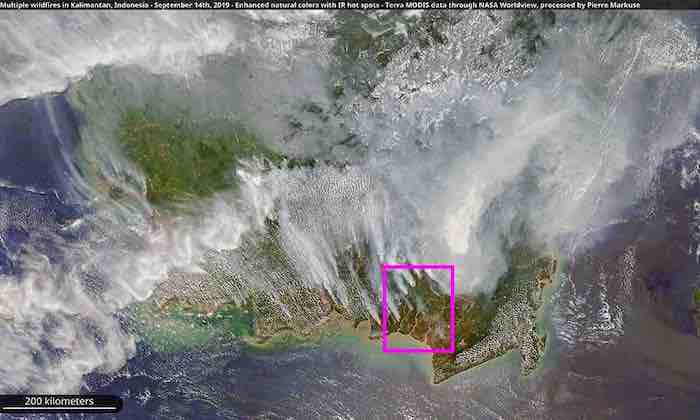
The above photo in this “documentary” shows a satellite shot with apparently numerous fires burning over a landscape of approximately 600 km in horizontal extent. Unfortunately, there are no captions, no date and no description of what it depicts. Given all the current fires in SE Australia, on first glance, it seemed to show that area, including the island of Tasmania on the bottom right.
Alas, Tasmania is not that close to the Australian continent and, hence, the picture must show a different area of the world. It took a bit of sleuthing to find the place. It’s the Indonesian area of Kalimantan, part of the island of Borneo.
Fires “burning” in SE Kalimantan, Indonesia, and enlargement; source: Malaysiakini.
The original source of this picture (shown nearby here) is a report at the website M'sian banks among top lenders to Indonesia fire-linked firms and has some interesting, real small script information (see the top line in white script on black background), that does not appear in the Gizmodo article picture. That information says:
“Multiple wildfires in Kalimantan, Indonesia – September 14th, 2019 –Enhanced natural colors with IR [infrared] hot spots – Terra MODIS data through NASA Worldview, processed by Pierre Markuse”
In other words, those red dots in the picture are not raging wildfires but smoldering hot spots not visible as such to our eyes but made so by computer embellishment. In fact, there is a nearly identical (unmodified) satellite shot of that area at Wikimedia that is devoid of any “flames.”
This information is critical to the understanding of what the Gizmodo picture actually shows. It is a vivid example of the new “world of virtual reality.” What is irresponsible and entirely false in the Gizmodo report is the (at least implied) statement that these wildfires are a sign of “climate change.”
They are nothing of that sort.
This is not to say that such bog fires where peat in the ground slowly burns without visible flame but extensive smoke generation are easy to combat. There was a small one in Germany a couple of years ago that took several weeks of concerted efforts to extinguish.
As the Malaysiakini report further states (via Google translator):
“The "ASEAN Haze Action" website states that 60% of the world's peatlands (about 24 million hectares) are concentrated in Southeast Asia, of which 70% are in Indonesia. Due to the improper management of peatlands by the Indonesian authorities, the slash-and-burn used in local traditional agriculture has made the fire[s] out of control, which has led to severe cross-border haze.”
That’s the real reason for these fires: the slash and burn method of turning forests into arable land.

Slash and burn is a time-honored tradition of turning forested lands into agricultural fields. It is still very much prevalent in tropical and sub-tropical areas all around the world, in Asia, Africa, and South America.
Of course, it has its drawbacks and consequences. Apart from the smoke and air pollution initially produced, the most pertinent and lasting effects are the changes in the biota and water table of the area. Erosion and soil degradation often follow. Subsequent drainage of the groundwater in bogs exposes the peat to air and potential combustion.
In SE Asia, vast tracts of ancient jungle have been deforested in this manner and turned into oil palm plantations. In fact, production of palm oil in Indonesia has, since 1964, recorded a phenomenal increase from 157,000 tonnes to 41.5 million tonnes in 2018 and a total of 51 million tons will be needed in 2025 to sustain international and domestic demands. Palm oil accounts for 11% ( $16.5 bn) of Indonesia's export earnings (https:/www.dw.com/en/palm-oil-too-much-of-a-good-thing/a-44979802 ). Indonesia alone produces over half of the world production of palm oil.
Furthermore, roughly one third of the Indonesia’s palm oil (including palm kernel oil) production is used as “biodiesel” fuel, much of which is exported to India, China, Europe, the U.S. and other countries.
These “wildfires” on Borneo are accidentally or deliberately set by the people and not evidence of any “climate change.” If anything, this picture demonstrates the new “virtual reality” that increasingly pervades our factual reality in too many ways.
Dr. Klaus L.E. Kaiser is author of CONVENIENT MYTHS, the green revolution – perceptions, politics, and facts Convenient Myths