By Dr. Ileana Johnson Paugh ——Bio and Archives--July 29, 2011
Lifestyles | CFP Comments | Reader Friendly | Subscribe | Email Us
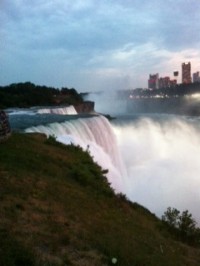 A few days ago, my childhood dream to see Niagara Falls became a reality thanks to my patient husband who loves to drive and explore. This is the best way to see our beautiful country, from the passenger seat of a comfortable car while gasoline is still available although not exactly cheap.
“Thunder of Water,” as the Indians call Niagara Falls, is a long journey from our home. We crossed Virginia into Maryland, central Pennsylvania, and western New York to the border with Canada.
Northern Virginia is a maze of traffic-congested highways sandwiched between lush forests and the mighty Potomac River. It is amazing that the woods are still populated by so many critters and birds, considering the heavy traffic and constant construction in all directions, at all hours of the night and day. The population is a hodgepodge of 225 different nationalities, most of whom do not speak English in public. There is a constant cacophony of languages no matter where you go. The population growth exploded in one county alone since 2000, according to the U.S. census, by 43.1 percent.
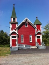 We stopped for the night in Wellsboro, PA, a city of times past, tree lined streets with gas light, where mom and pop stores are still in business on Main Street, the heartland of America of nostalgic years, a Mayberry U.S.A.
Our Mary Wells hotel was built in 1860 and had interesting original fixtures and furniture reminiscent of a movie set. The hallway lighting cast dark and spooky shadows on the scrolled blood burgundy wallpaper. The doors had real brass keys with a large fob. The tub and sink dated back to the turn of the 20th century. Four faucets adorned the tub and shower while the water sprang from the sink like a waterfall. The restaurant’s walls were adorned with photographs of the long-ago but not forgotten town when life was harder but much simpler. The nearby diner owned by a lovely Mennonite family had been in continuous existence for 72 years. People were hospitable and serious, European in their demeanor.
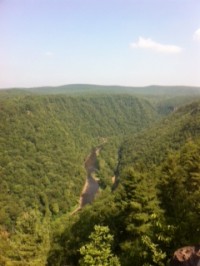 Ten miles from Wellsboro, nature has carved a 47-mile long, 1,000 feet deep gorge, Pine Creek Gorge or Pennsylvania’s Grand Canyon as the locals call it. At the highest peak, the bottom of the gorge can be seen from almost 2,100 feet. Three hundred thousand unspoiled acres with tumbling waterfalls can be admired from Colton Point State Park and Leonard Harrison scenic overlook. The 63.4-mile trail was voted by USA Today as one of the “10 great places to take a bike tour.” If only I could bike or walk, what a fantastic experience!
The beautiful Allegheny National Forest dots the landscape of western Pennsylvania. The roads are smooth and the grade is so steep for some stretches of the highway, big rigs have to drive 30 mph. I wondered what it would be like to maneuver such inclines in snow and ice conditions.
As soon as we crossed the border into New York, the roads became instantly bumpy and broken. I wonder what New Yorkers do with their high taxes; road repair does not seem to be a priority. We had hoped the conditions would improve as we approached Buffalo but that was not the case. I was pondering where the Stimulus I and II money was spent; part of it was dedicated to road infrastructure and bridges. It did not make it to the highways we traveled. We stopped at a gas station where a package of Marlboro cigarettes cost $8.66. How do New Yorkers afford to burn money, pardon me, smoke? A pack of cigarettes cost about $1 to produce, the rest is taxes. The smoking population seems to shoulder a heavy tax burden for their addiction.
The road cut Buffalo in two, a dilapidated section on the left and the developed downtown, shining in the distance. As we left Buffalo, my excitement grew as we were only 20 minutes from Niagara Falls, U.S.A. Since Niagara State Park is the oldest park in the U.S., established on July 15, 1885, I expected sort of a frontier town look to the place. I was sadly disappointed, the town itself had the look of a pot-holed city with 30-40 year old buildings and homes dotting the city on the way to the well-maintained park.
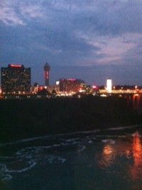 My disappointment grew when I saw the Canadian side of Niagara Falls, a beaming, shining, spectacularly ultra modern city with skyscrapers and amenities of the 21st century. It was a poor brother-rich brother example of heavy investment in infrastructure on the Canadian side and non-investment on the American side. However, the Niagara Falls State Park, obviously beautifully maintained through admission tickets, did not disappoint.
The Maid of the Mist boat ride brought us as close to the roar of the fall as we could be without being in a barrel in the roiling cauldron. A comfortable and cool elevator brought us 175 feet down to The Cave of the Winds, close to the falls. 37,000 gallons of water falling per second, generated winds in excess of 70 mph that were buffeting the area, the closer you got to the falls.
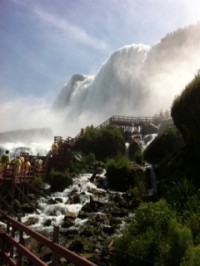 Luna Island, Goat Island, and Three Sisters Islands took us to different vantage points of the American Falls and the Canadian Horseshoe Falls. A convenient scenic trolley helped those who could not walk great distances. I have seen so many rainbows but I am yet to find my pot of gold.
Since 9/11, Americans and Canadians can no longer travel freely between each country without a passport although a very short bridge separates the two sides of Niagara Falls. I had my passport and decided to limp across in order to take in the better view of the falls from the Canadian side, especially since nightfall was approaching and the falls were illuminated from the Canadian side. What a glorious view to behold forever in my mind’s eye when I need moments of calm and tranquility!
 I spent a couple of hours on the Canadian side. Upon return, I was confronted with the reality of having to pay a bridge toll of 50 cents. That is an insignificant amount, the problem was that nobody knew about this toll and every American was digging through his or her pockets to find change. A nice Puerto Rican family of five found enough change to include me. I was saved by my instant Puerto Rican friends. Who knows, I might still be in Canada today and that might not be such a bad thing. I had carried my credit card only for emergencies, knowing that sales tax in Canada was 19 percent. The actual tax was 13 percent but the city voted to levy an extra tourist tax of 6 percent.
We left very happy, having seen the falls and having fulfilled my childhood dream. We were totally soaked several times each day. It was a relief of sorts, the normal milder temperatures of the area were replaced during our three-day stay by extreme temperatures of 100 plus degrees. Our soaked clothes kept our bodies comfortable for hours.
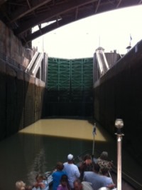 We could not leave the area without experiencing the Erie Canal Lockport 34-35. Being inside the double locks that raised our boat by 50 feet in sheer minutes was a marvel of technology that shaped our modern life and allowed commercial access all the way to the Hudson River and eventually to the Atlantic Ocean. My eyes were a bit wide watching the 280-ton gates close and open on each side holding in so much water to allow us passage to the next level up or down of the Niagara River, 556 feet above sea level.
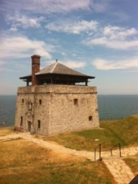 The last stop was Fort Niagara in the U.S. and Fort George in Canada. We are history buffs and know the importance of these forts dating back to 1759. Three empires fought over Fort Niagara (the French, the British, and the Americans). Fort Niagara was considered at the time, the lynchpin in controlling the New World. It was a bright, hot day but the thick rock walls and adjacent buildings offered respite from the excessive temperatures. The azure blue waters of Lake Ontario were teeming with sailboats between United States and Canada’s shores. A short bridge separated the two countries. After experiencing the canons and the muskets being shot, we said good-bye to this fort that decided the fate of three empires, and started on our journey back.
View Comments
Dr. Ileana Johnson Paugh, Ileana Writes is a freelance writer, author, radio commentator, and speaker. Her books, “Echoes of Communism”, “Liberty on Life Support” and “U.N. Agenda 21: Environmental Piracy,” “Communism 2.0: 25 Years Later” are available at Amazon in paperback and Kindle.