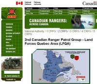
Quebec’s decades old refusal to accept the official boundary between itself and the Province of Newfoundland and Labrador, specifically in the area of Southern Labrador is an issue that cannot be ignored.
The boundary was officially determined by the Privy Council in 1927, more than 20 years before Newfoundland and Labrador became Canada’s newest “Colony” and was recognized by the Canadian Constitution when it was written into the Terms of Union in 1949, a fact that Quebec continues to openly ignore.
All official Quebec maps depict a border which extends well into Labrador.
This is an issue that has been on the radar of Web Talk and many of its readers for a long time now and while the provincial government recently issued a letter of concern over maps in use by a federal / provincial panel reviewing the environmental impact of Quebec’s Romaine River hydro project, little else has been said about the issue thus far.
Personally I couldn’t care less if the government or people of Quebec want to delude themselves. The real problem becomes clearer when one considers the potential for Quebec’s position to be accepted outside that province.
They say perception is reality and the boundary issue is a perfect example of this adage.
Quebec has been using their “corrupted” maps for so long now that they are now beginning to convince Federal agencies that their fantasy is factual.
The use of erroneous maps by a joint Federal / Quebec environmental panel, which finally spurred the Newfoundland and Labrador government to voice its concerns, is just one case that proves the point.
Shortly before publishing the February 12th article Web Talk, brought the issue directly to the attention of the provincial government in an effort to determine where they stood on the issue.
Instead of simply focusing on maps issued by Quebec, Web Talk presented copies of maps currently in use by multiple Federal agencies, including the CBC and the Department of National Defense.
Minister of Natural Resources, Kathy Dunderdale, responded by revealing that the provincial government was not aware of the actions of those federal agencies and confirmed that the province will be contacting those agencies to ensure that they do not continue the practice.
According to the Minister, "The inaccurate depiction of the boundary between Newfoundland and Labrador and Quebec...is a matter of concern for the Province. However, we are confident in the legal and binding nature of the interprovincial boundary as set out in the 1927 decision of the Judicial Committee of the Privy Council and the Constitution of Canada by Term 2 of the Terms of Union of Newfoundland and Labrador with Canada."
"The Government of Quebec is well aware of our displeasure about their use of the fictional boundary. Their continued use of that depiction is disrespectful, but will have no real effect on the constitutional reality of Canada."
"The inaccurate depictions of the boundary in images used by the federal government and the Canadian Broadcasting Corporation are new developments and we appreciate you bringing them to our attention. We will contact the Department of National Defense and the CBC to ensure that these errors are corrected immediately."
"...we will continue to be vigilant in the protection of our sovereign territory, including the Labrador/Quebec boundary."
 Web Talk Exclusive:
On several occasions over the past years Web Talk has brought the Quebec / Labrador boundary dispute to the attention of its readers. The most time was in the February 12th article, “Through the Looking Glass – A Constitutional Crisis in the Making”.