Tipping is fine but “climate tipping points” are nonsense. I’m talking about climate models that have predicted such “points of no return.” You could view them as the terminal (maximum) speed in a free fall, only to come to a sudden stop when you hit the solid ground.
For example, the disgraced chairman of the IPCC (UN Intergovernmental Panel on Climate Change), R. Pachauri, declared in 2007 that the world had only about four years to save itself. The perceived danger: a runaway (tipping point exceedance) global warming that he claimed to result from carbon dioxide released by burning fossil fuels. The following year, 2008, one of Germany’s high priests of climate doom, Prof. S. Rahmstorf, Head of Earth System Analysis at the Potsdam Institute for Climate Impact Research (PIK) produced a graph showing the then observed
decline of sea-ice in the Arctic’s summer (Fig. 1).
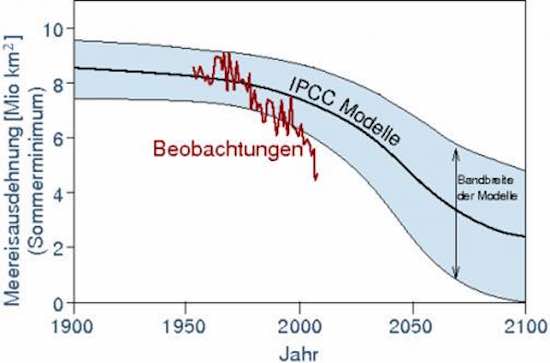 Fig. 1. Observations (“Beobachtungen”) vs. IPCC models of summer sea-ice in the Arctic; from Rahmstorf, 2008.
Then, in 2011, Rahmstorf publicly mused about more ice loss in the Arctic and “
Two types of tipping points.” (The IPCC defines tipping point “as a
threshold for abrupt and irreversible change”). To explain his theory, he showed a conceptual graph where, initially an increasing decline of Arctic minimum sea-ice that reaches a point of inflection after which the decline will be slower but still lead to a near ice-free situation not much later, reproduced here in Fig. 2.
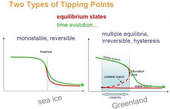 Fig. 2. “Tipping points” as per Rahmstorf, 2011.
Just to make sure that the readers got the message he wished to convey, he claimed “[translated]: There is no reason for any “all-clear signal” [with respect to sea-ice in the Arctic].”
Then, in 2012, in another lecture, low and behold the ice had declined even further compared to 2008 and he expanded on it (see the red line in Fig. 3). The decline appeared to be rapid and unstoppable. Surely, the point of inflection in the models (black line) had well been past. Rahmstorf again made certain that the audience took home his message by emphasizing it with statements like [translated] „Last month, the [Arctic] ice cover was only approximately half the size of that in 1979” and “the actual development shows that the ice melt is much faster than the models predicted” and “unfortunately the problem [of Arctic ice melt] has in the past been strongly under-estimated; and it keeps thinning.” The entire lecture is available at [url=https://vimeo.com/56007848]https://vimeo.com/56007848[/url] .
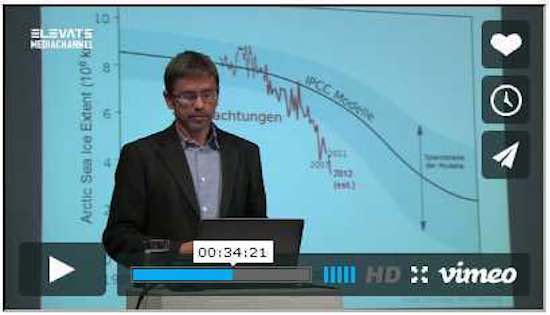 Fig. 3. Screenshot of Rahmstorf’s lecture in 2012, where he is showing more decline of Arctic sea-ice and stating “…the decline is much faster than the models predicted; and the ice keeps thinning.”
Now to the Real World
In the following, I’d like to look at a few examples of that tipping point theory and what became of it.
1. Global Warming & Arctic Sea-Ice
Ten years ago or so, the IPCC and many “climate modellers” were all in rage: They claimed that the world was in a run-away overheating situation. They also claimed to know why: rising carbon dioxide (CO2) concentrations in the atmosphere.
Despite steadily rising CO2 levels since then, the warming trend has stalled for 18+ years now. Obviously, nature missed to learn from Rahmstorf’s lecture and the IPCC predictions or we all would be fried by now.
This “climate tipping point” was (according to PIK’s models) to be particularly apparent in “the most sensitive” area for that, namely the Arctic. If you compare Rahmstorf’s 2008 graph (Fig. 1) with his updated version shown in 2012 (Fig. 3), you really might have fallen for that theory. In fact, Rahmstorf even stated that “the ice extent is declining much more rapidly than predicted by the (then current) computer models. To top off the finger-wagging, he added “and it is getting thinner.” If that statement was not give the message of being past a tipping point already, I don’t know what it was meant to convey.
Once again, nature did not listen. In recent winters and summers, the northern sea-ice extent returned to normal (Fig 4).
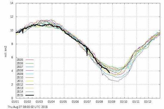 Fig. 4. Northern hemispheric sea-ice, 2005-2015, source: Danish Met. Inst.
Perhaps then, we ought to look further south in “the Arctic,” like the North American or Laurentian Great Lakes (GLs) to get a better picture.
2. Laurentian Great Lakes (GLs)
Now, personally I don’t think that the freshwater Great Lakes are part of the Arctic though it can be quite cold around their shores in winter (and, sometimes, even in summer). However, considering the definition for Arctic sea-ice, the latitude of the upper GLs (Lakes Superior, Huron and Michigan) are certainly within the latitudinal bounds of Arctic sea-ice measurements.
Anyway, the water levels of the GLs have been recorded for over 150 years and such
records are widely available.
Beginning with 1980 or so, the level in Lakes Huron and Michigan (LHM, which is identical because of the wide gap at the Straights of Mackinac), was getting higher and higher to reach a new 150-year record in 1986 (Fig. 5). Many lake shore property owners then feared a “tipping point” breach and clamoured for the government(s) “to do something.”
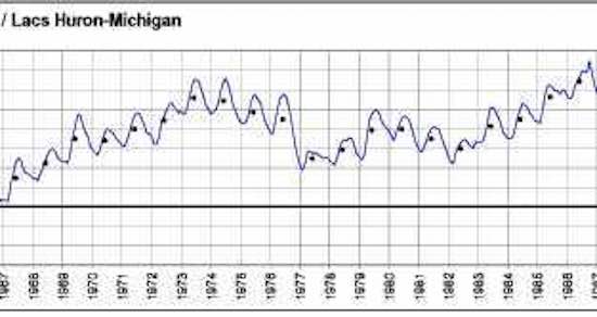 Fig. 5. Lake Huron record high water level in 1986, and near record low in 2001.
Of course, governments need a while to respond to new situations, so, for a number of years they didn’t do anything to curb the rise. But they didn’t need to do anything after all; nature changed her mind and decided to lower the water level all by her little self. By the year 2000, the water level in LHM had declined sharply, nearly two meters below the 1986 level and it stayed there for a dozen or so years. In fact, a new all-time (150-year) record low level was reached in 2012.
Needless to say, all the people who wanted the government to “do something” about the perceived “for-ever-rise” in the mid-1980’s changed their tune and were then clamouring for the opposite government action, namely to “stop the drop.” Large “Stop the Drop” banners could be seen at all kinds of places around the lake. Had we reached or even surpassed yet another “tipping point?” It looked that way to many.
Just when everyone was convinced that the lake levels of the 1970s were never to be seen again, Mother Nature changed her mind, once again. Between 2013 and 2015 (this year), LHM levels shot up by 1 m (3.5 ft) and are currently 1.2 m above the 2012 record low. In fact, they are now again much closer to the record high of 1986 than to the record low of 2012 (Fig. 6).
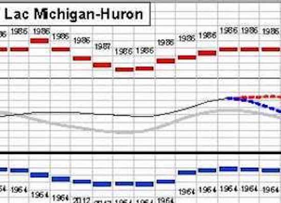 Fig. 6. Lake Huron water level in 2015, once again well above the long-term mean.
All nature needed to provide was a regular amount of rain and snow, and a couple of cold winters in a row with little wind. If you wonder how those determine the water levels in LHM, see below in section (3), if not, you can jump right to section (4).
3. Your Ice Cubes
Your ice-cubes-to-be in the fridge freeze from the outside, not the inside. The air in the freezer needs to be colder than the freezing point of the water (0 C) for that to happen. With lakes, it’s the same. When the air is colder than that, they tend to freeze over – unless the warmer (4 C) bottom water mixes with the 0 C surface water and keeps it from freezing. With deep lakes like L. Superior and L. Huron (maximum depths 406 m and 229 m, respectively), there is an enormous amount of latent heat energy stored in that relatively warm (4 C) but nevertheless quite cold water. Just a little breeze will do to create the wave action necessary to stir things up sufficiently for the surface not to freeze over.
However, when it’s calm AND cold, the surface will develop a layer of ice over night. A few more days and nights of the same will do the trick. The entire lake surface freezes over and may stay that way for the next few weeks or months. Without any strong wind action or ship traffic to break it up (like it happens in the Arctic summer, see my previous post on
Breaking Ice in the Arctic), that layer of ice reduces the evaporation rate to a fraction of the normal.
The reason is the large difference between vapour pressure of water molecules on the surface of (unfrozen) water and cold ice. In winter, the moisture content of air is very low. For that reason people need to humidify their houses in order to keep at least happy if not healthy. Without humidification, you are nature’s target for getting zapped by a high voltage discharge at every step or so; it can be annoying.
Now back to the water and ice. In order to evaporate H2O (water) molecules from any surface, the evaporation energy needs to be supplied. That is easily obtained on an open water surface (at 0 C) by the warmer water below. In contrast, a poor heat conductor like ice can only take it from the ice immediately below the surface and only with a considerable delay from the water below the ice. Together with the much lower vapour pressure of cold ice, it results in much less evaporation from the lake in a cold winter with ice cover. The magnitude of that difference can be astounding, up to 0.5 m (1.5+ ft) of lake level drop in a “warm” winter (without ice cover) and next to no drop in a cold winter with full ice cover.
I quite agree, this is a bit counter-intuitive but true nonetheless. Of course, people who model nature’s escapades from a cozy “climate office” may find it difficult to explain that to their super computer; perhaps, a (permanent) move to the real Arctic would teach the right lesson.
4. Tipping Point Theory -- and Practice
The gurus who have warned of climate tipping points and predicted a runaway-warming, melting ice, rising sea levels and so forth invoking the tipping point idea were all quite coy about exactly what numerical value(s) they considered as the tipping point(s) in this or that measurement. In fact, I suspect they had no idea themselves – and for good reason – as there are no tipping points in such things as temperature, ice extent, etc. They are physical measurements that are observed on earth over a wide range and can vary tremendously at any given location and in short time. There are no points of no return in such natural variations many of which can exhibit large amplitudes and lengthy cycles.
For example, at the same time of year (late-August) at a friend’s place up north, the conditions have varied over the years from near freezing to 30+ C, from dead calm to violent storms, from lush green plant cover to the severe droughts with the maple trees shedding their leaves for lack of water and oak leaves just shriveling on the stem up while still green, and a 2 m lake water level change first to a 150-year record high and then back to a 150-year low. In all those extremes over several decades, I have not noticed any tipping point from which there was no return to longer-term normal levels or even the opposite extremes.
How quickly nature can reverse course was also seen in Australia not long ago. After years of below-normal precipitation the
Great Artesian Basin aquifer had lost much of its water. Then, in 2011 and 2012, so much rain fell that it replenished the reservoir for many years to come. Of course that water was evaporated from the ocean and it was claimed to have lowered the ocean level by 7 mm or 1/3 inch. You can also look at more historic events, for example the decades-long droughts in the southwest of the U.S. that forced many of the pueblo cultures to abandon their long-held settlements. Since that time the areas have undergone more recovery and drought cycles.
In other words, the entire climate tipping point theory is pure bunk.


